|
WHAT IS GIS?
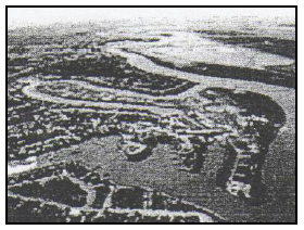
Definition: GIS is an organized collection of computer hardware, software, geographic data and personnel designed to capture, store, update, manipulate, analyze and display geographically referenced data. You are to read through the handout on GIS and complete the following practice questions for your text next week. The questions below are to be answered neatly in your Social Studies Journals: Question 1: Data manipulation is used to control how features are represented on small and large-scale maps. 1.1 Explain the meaning of the term data manipulation. (1 x 2) (2) 1.2 Explain why it is necessary to manipulate data on maps. (1 x 2) (2) Question 2: Two learners from a school in Paarl have an assignment and have to take photographs of the Berg River. One has a 2.0 megapixel camera and the other has a 3.5 megapixel camera. The resolution of the photographs taken by the boys will differ. 2.1 Explain the meaning of the term resolution. (1 x 2) (2) 2.2 Which one of the cameras will take better quality pictures? Explain your answer. (2 x 2) (4) 2.3 Heavy rainfall sometimes results in flooding along the Berg River, as is evident in the image below. How could the local government use GIS to manage this disaster? (2 x 2) (4)
2 Comments
mohammed abdullah
24/10/2016 07:37:37 am
where am i supposed to find the line and polygon thing?
Mr Craig
24/10/2016 08:25:12 am
Hi Mohammed, Your comment will be posted after it is approved.
Leave a Reply. |
Social StudiesThe study of social Archives
May 2017
Categories
All
|
 RSS Feed